17
Jan 12

Skiing at Feldberg

Black Forest is pretty overall, and in winter there are nice skiing possibilities for cross-country skiing. There are some downhill slopes as well, although mostly just kiddie type. Even the biggest local slope, Feldberg, is just a molehill really (not to mention the lift is so overpriced for what it is). But when the weather is good, it provides good fun nevertheless, and beautiful Alp views on top.

Gina in full gear

Gina with a view - note the active volcano in the background

Iestyn does not ski, so he walks around and takes pictures. And also tests our new fancy red moose thermos, which keeps tea nice and warm for a long time. All the way until the sunset.

Moose with a beard

Sunset

Here’s the panorama I took while Gina was skiing away all gloriously:

A sunset over Feldberg

Sunset Over Felbreg


25
Dec 11

Schauinsland on christmas day

After unwrapping our beautiful presents in the morning (we must have been good last year, especially Iestyn), and having lots of christmas cookies and other sweets, we decided to go for a short walk up Schauinsland, to make space in our bellies for the epic christmas dinner. We could not really have gone for a longer walk, as epic christmas dinners take a long time to make (even though we already prepared lots of stuff the day before).

Looking back to F'burg

Schauninsland was full of snow, and had a strange lid of grey clouds hanging over the whole of the sky, except at the end over the horizon, where the sky ran out of clouds and showed some Alp peaks in the sun. We went up the tower, and both of us made it all the way to the top, which was great. Iestyn made pictures, while I was playing with the tiny icicles made by snow and wind.

Gina

Iestyn

View


20
Dec 11

Christmas Cookies!!

The first Christmas we spent together was back in 2009. Gina flew over from Praha to Wales to spend some time with me, and to my delight, bought with her something that was totally new to me; Czech Christmas cookies!! She didn’t just bring a handful, oh no – she bought with her a box full, about 2kg. They were epically delicious. From then, I’ve always wanted more, and due to us not being able to spend last Christmas together, Gina made some more epic Cookies!

In preparation, Gina created the dough over in Prague when she headed there for a couple of days, but the epic task wasn’t over, as we had a very productive day, watching National Lampoons Christmas Vacation, and baking to the max!

A very busy Gina

Heart Shaped Cookies

Gina went ahead and started cutting the dough with our newly bought cookie cutters, into various shapes, such as hearts, half moons, bear paws, christmas tree, shooting star (comet), rounded ones, and some with holes in the middle. We had a pretty good system going, with Gina doing pretty much all the work, and me chilling :) That is, until the epic task of filling in the holed cookies with Gina’s mum’s homemade Jam.

Iest being busy

Heart Shells

Then, while Gina took a wee break, I was left in charge – only temporarily, to cut up the dough into nice wee heart shapes. Gina got busy, snapping away. Once the cookies were ready, they were sent away into the over to be baked, and when finished, laid out by the window to cool, and to fill the apartment with their beautiful smell.

Baked Hearts

Hazelnut Moons

Cocnut Christmas Shapes

Chocolate Dipped!

Then, sadly, the cookies were taken away, and stored in our nice cookie boxes until they were ready to eat – which was about two weeks later. When they were brought out, we could munch on as many as we wanted – although, I was banned from opening the boxes, as Gina knew damn well, that I’d eat them all. They were delicious, and I’m already looking forward to next years batch!!

Chocolate cooling production line

Cookies and our Tree


27
Nov 11

St. Peter, St. Märgen

First advent Sunday, sunny but cold with fierce wind – we decided to go for a mellow trip. There are two monasteries near Freiburg, in beautiful locations in the midst of Black Forest hills. We first visited Sankt Peter, which was pretty but the service was in full blow (and no, we did not think of it ahead), so we could not really admire the insides, and the historical library was closed already. Outside there was not much to do (did I mention the awful biting wind?).

St Peter

Between St Peter and St Margen

So soon enough we were on our way to Sankt Märgen. They had a christmas market going on, on which I got a pretty little heart-shaped decoration for our wall. We also checked the surroundings and the horse, and called it quits (I mentioned the arctic wind, right?)

Sankt Märgen

Sankt Märgen

Sankt Märgen


19
Nov 11

Llyn y Dywarchen

Llyn y Dywarchen

Llyn Y Dywarchen; ‘The lake of the Turf Island, is a lake steeped in myth and legends. It’s a small lake, located above the village of Drws y Coed, in Dyffryn Nantlle, which sits between Y Garn and Mynydd Mawr which rises sharply at either end of the shores.

As mentioned in the ‘Llyn Bwlch y Moch‘ post, in the 19th century the lake was extended by building a wall on the South side of the lake, and also, the direction of the river flowing out of the lake has been changed, from flowing down the River Llyfni into Dyffryn Nantlle, to now, flowing into the Afon Gwyrfai, and into Llyn y Gadair – just behind Rhyd Ddu.

It’s the lake that Gerallt Gymro (Geraldus Cambrensis – an early historian) described when he wrote about a floating island on a lake, as he and his party passed the lake on the way to Caernarfon, while they were enlisting men for Third Crusade in 1188AD. The floating island was either made of turf, or a slab of peat that broke away from the mainland, or detached itself from the bottom of the lake and floated to the surface, and was being kept afloat by the gasses, such as methane  that came out of the marshlands. He noted that farm animals would often be seen marooned on the island, as they would walk on the island while it was resting on the shore, and it would suddenly drift off.  The scientist Edmond Halley (of the comet fame) confirmed that the island was indeed floating, as surrounded by on-lookers, he swam out to the lake, and started rowing – to which the lake floated along! But, unfortunately, the Island we see in the lake today, isn’t the famous floating Island.

There are many legends surrounding the shores of Llyn y Dywarchen. This is the land of the ‘Tylwyth Teg or the little people. As the Legend goes, a young man was returning home to Drws y Coed from Beddgelert, on a bright moonlit night, and came across a number of ladies known as the Tylwyth Teg, who were going about their nightly tradition of dancing and frolicking. Charmed by the beauty of the Ladies, he fell in love with one, and leaped out into their circle, and stole one of the Tylwyth Teg and wanted her to be his wife. She refused, but became his maid instead, but if he found out her name, she would marry him. He heard the other ‘fairies’ talking about her one evening using her name, so she married her with a warning not to touch her with iron. Unfortunately, while attending to his horse one day, an Iron buckle from the saddle touched the Tylwyth Teg, which in a blink of an eye, caused his beloved to disappear for ever.

Another short legend from the lake, is about another man who spotted the Tylwyth Teg one evening, going about their nightly frolics, and invited the man to join them. They danced away, resulting in the man being transported away to a beautiful country, from which it took 7 years to return.

I don’t know much about the old building which once stood where the car park to the lake is now, as I can’t seem to find any information about it online.


17
Nov 11

Llyn Bwlch y Moch, Drws y Coed

Llyn Bwlch Y Moch

Tucked away, North of Llyn y Dywarchen, contouring around Clogwyn y Garreg, now lies a strip of marsh lands. Older maps, dating back to the nineteenth century also show a similar site of marsh lands at Bwlch y Moch, but as recently as 1962 – Ordnance Survey maps showes a lake at Bwlch y Moch – Llyn Bwlch y Moch.

The secret to this mysterious lake, can be found if you examine the head and foot of Llyn y Dywarchen, you can see that man is responsible for the lake. Llyn y Dywarchen rests at the natural watershed between Llyn Cwellyn and Llyn Nantlle.

From different books and articles I’ve read – it sounds like the marsh lands which are now Llyn Bwlch y Moch was the natural soak away for Llyn y Dywarchen, which took the water down the Nantlle Valley – flowing mightily on the Afon Llyfni into Llyn Nantlle below.

Then, two damns were built on Llyn y Dywarchen, closing the flow altogether into Cwm Bwlch y Moch – which raised the water level at Llyn y Dywarchen. With the exit into Llyn Bwlch y Moch closed, the flow changed direction into the Cwellyn system, through an artificial water channel – which altered the direction to which it used to flow, which is now South to Llyn y Gadair, just by Rhyd Ddu.

By the North head damn of Llyn y Dywarchen, lies a ruin of an old cottage and some weathered looking Sycamore trees – which could be the reason to the naming of the Cwm (cirque) – as the ruined cottage’s outhouse has a wall with a low aperture, which suggests that Pigs might once have been living here? (Moch = Pigs in Welsh) Another reason might be that Clogwyn-y-Garreg, the crag that overlooks the Cwm looks like the profile of a Pig when viewed from Cwm Nantlle below? Or it might refer to our Welsh prose stories, Mabinogion, where a boar guides Gwydion to Nantlle in search of Lleu?

At the Northern foot of the lake, there’s evidence that the lake once was very important in supplying the old copper-works located below in Drws y Coed, as there is a great stone damn. (Evident in the first picture as a straight line at the end of the  lake) The center of the damn has now been dismantled, to ensure that the lake doesn’t fill up again, which is a shame, as I think this peaceful spot, hidden away from the road would be a fantastic stretch of water.

So, this damn explains why the first Ordnance Survey maps didn’t show any lake at this spot – the lake only existed after the damn was build in around 1840 – to serve the copper mines below, and was still a lake according to the Ordnance Survey maps until 1962, long after the closure of the mines, and after breaching the damn again, sometime after 1962, the lake was drained again, and left to be the marsh lands that we see today.

Dad knows the farmer that lives in the farm directly below the damn, he’s going to enquire more from the farmer about the lake and it’s history for me, so I shall update this page in the future!


29
Oct 11

Wutachschlucht

As Gina has been away for a couple of weeks in Sarajevo, Bosnia with work, we hadn’t been anywhere for a bit. I went with a friend to stay for the night at the Wutachschlucht, and when Gina got back, I showed her the photos I took from our trip, which was a very nice trip – but very misty and steamy weather.  Gina thought it would be fantastic idea (well, in reality I said something along the lines of ‘let’s go somewhere or whatevs’) to head on down there again, as it was a glorious sunny day – she was right (as usual). The valley in the sun was a whole different place, really nice.

Wutachschlucht is a narrow gorge, with about three different sections. It’s believed to be the youngest valley in the whole of Europe, which formed about 10,000 years ago when the Ice retreated. It’s a beautiful place, full of wildlife and vegetation. The route we took was roughly 14km long, that starts from the village of Bonndorf and ends close to Wutach – where we were to catch the tourist bus back to Claude…

We headed out early, and missed the morning traffic. Driving up the Hollental Valley out of Freiburg is always a pleasant experience, but in the Autumn, the whole Valley shines in epic Autumn colors – something I’ve always wanted to see here in the Black Forest.

Arriving in Bonndorf, we left Claude at the car park, and headed North towards the valley. Gina was armed with my camera, and happily merrily took some photos of the Autumn scenes all around.

Autumn Berries

Autumn Leaves

Autumn Colours

We headed down into the gorge, and began following the stream steadily downhill. It’s a great big deep valley, which gets deeper really quickly, and without knowing it, you get dwarfed by the 100 year old trees that surrounds the gentle stream. There are some nice bridges that cross the river frequently, which makes the trek very ‘tourist friendly’ – which it certainly was on this sunny Autumn day.

Gina on the bridge

Gina in the stream

As we continued happily down the stream, the gorge opens up, and the stream joins a huge river, and  you start to see all around. Today, from what I can gather, was Gina’s day of experimenting on new techniques with the camera that she’s recently learned from somewhere. One of the techniques she liked today was what she called ‘Fast Zooms’ :) (never called it that once. I call it ‘motion pictures’)The results are posted below (truth said, a little bit too much motion in the second one. But the first one came out right.):

Gina on the river

Gina Smiles

Gina's "Fast Zoom" Experiments

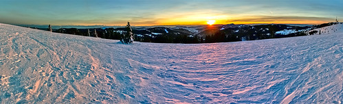
After walking along the wide river peacefully, the path takes a pretty great gain in height, and without knowing it, you suddenly become very high. One particular place, roughly just under half way, offers an amazing view of the river and valley, which I took the opportunity to take a panorama:

Panorama View

As you can see, the Autumn colors really make the place look amazing. As we continued further, the terrain changes again, this time, the river flows along, and carves into these great big Limestone cliffs. The cliffs themselves looks so strange, as you can clearly see the layers of rock so clearly.

Iestyn Canyon

Gina Canyon

And this is pretty much the end of the tour of the Valley. From here, it was a gentle walk though some trees, and over a few bridges, and along the river. As the tour was winding down, still on her Experimenting high, Gina also took the opportunity to create some lovely macro shots of the vegetation (oi! i’ve had macro under my belt practically before you were born – this was no experimenting! just doing what I do best.).

Gina's Macro Experiment

We came out the other end, just by the bus stop where the bus would take us back to Bonndorf, and to Claude. But, with a bit of detective work on the timetable, we figured out that the last bus had indeed left about an hour earlier, so we were faced with an interesting situation – how do we get back to Claude, that was sitting lonely 14km away? To think about it, we headed to the hut at the side of the road to have a delicious, well earned coffee and cake:

Eating Plum Cake

Gina Eating Cake

After filling our bellies, we’d decided that we couldn’t call a taxi to come and pick us up – so the only other option was to try our hand at thumbing. So, we headed back to the bus stop, and using my best thumbing moves, we managed to pull the third car over – which was also heading to Bonndorf – result! Our driver was originally from Bonndorf, so he knows the situation with the bus very well, and because we looked like a cool pair of hikers, he decided to pick us up. He took us all the way to Claude – which was fantastic, as we both really didn’t fancy walking back.


16
Oct 11

Welsh Rugby and Schauinsland

We got up super early, and headed into town, wearing our lovely new Welsh Rugby shirts (Diolch yn fawr mam a dad!) to support the Welsh Rugby team in the Semi Finals vs. France. Our destination was our local Irish Pub, O’Kelly’s – which is a proper Irish Pub, here in Freiburg. As we walked in, the  pub seemed to be full of French supporters, so we had a quick look around, saw some Welsh supporters sitting in the corner, and decided to join them. As it was (almost) the crack of dawn, there was no beers or the like for us, as we sipped some nice coffee and tea to watch the game.

Gina at the O'Kelly's

Guiness Coffee

Unfortunately, due to some mishaps in the Welsh team, with the lack of kicking the ball over the bar in the penalties, we didn’t get through to the Finals of the World Cup. But we both agreed that Wales was the best team, as we managed to ‘run the ball over the line’ more time than the ‘French sissies’. I had fun watching it with Gina – I hope we’ll get to watch some more matches in the future!

Us

After a busy day in the shops of Freiburg, we decided to go for a wee drive with Claude to the Schauinsland area, to try and catch the sunset, which was a great idea, as the sun went down with a brilliant red colour.

Sunset (just under) Schauinsland

We didn’t make it all the way to the top of Schauinsland, as we would have missed the setting sun, but the nice lay-by was good enough for us, as the view was beautiful on this Autumn day.

Gina Smiles

Iestyn glowing beard

From here, we continued along the road to the other side of the ridge, where we could see down into the neighboring valley, where Gina took this lovely panorama of the Black Forest.

Schauinsland

It’s nice starting to feel the Autumn air here in the Black Forest, as the evenings are getting much colder and fresher, the sun starting to sink lower in the sky, and I cannot wait to see the foliage turn into the fiery Autumn colours, as all we can see here is trees, I predict it’s going to be mighty fine!


02
Oct 11

Hochfirst

We wanted to get up real early and go for a long hike but of course that idea didn’t go down so well with people who wanted to have a ‘proper Sunday lie-in’ cause they never get to sleep in, so there we were, stuck in a traffic jam quarter to noon on the road to the Höllental valley. Oh well, it cleared up quickly, and the drive through the valley was pretty as ever.

We arrived in Saig, and despite Henry trying hard, we couldn’t find parking in the village. Eventually, we just left Claude in a little clearance by the forest behind the village, hoping noone would tow him away. But the village seemed pretty sleepy and quiet, so we didn’t really think anyone would bother. Of course, once we started walking, we found the parking place in Saig all ready.

Saig is a very small and traditional schwarzwald village, couldn’t be more stereotypical if it tried.

Saig church

Saig pointers

From Saig we took the steep hill up to Hochfirst. From there we had a beautiful view down on the Titisee area.

Hochfirst view

But that was not enough for us, we decided to go up the watchtower as well! The watchtower looked like a mobile transmitter or something like that but had a nice double winding staircase inside, and a platform up on top with legend for identifying mountains and hills around. Unfortunately, the horizon was quite hazy, so we could not see the Alps. We did have a nice chat with a German dude, who started talking about the tower falling over as soon as he heard from Iest that he does not enjoy heights.

Iest by the tower

Hochfirst tower

Gina Tower

When we had enough of disaster scenarios we decided to go on with our trail, which led us along the Beerwaldhauptweg. This was all through the forest, which Iest found nice, since they don’t have forests where he comes from, I found it a bit boring, although quite bearably. We also found one nice hut with an autumn view and forgotten digital camera on the inside (curiously, with some antipodean pictures on it), we left it there.

Beerwaldhauptweg

Autumny hut

We were looking forward to seeing the Francosenkreutz commemorating the fallen in a battle between the French and the Austrians in the aftermath of the French Revolution in 1799, but we were kind of disappointed.

Franzosenkreuz

However, the village Kappel was really nice with beautiful old farmhouses and spunky cows.

Kappel chapel

Kappel

Kappel cow

We were happy to find Claude where we left him, waiting for us all good. And we headed home after a nice little walk, looking forward to our yum cake, also waiting where we left him.


17
Sep 11

Triberg

The morning was quite sunny and fresh, but the forecast for today was really bad, so we didn’t want to go for a long trip, just something quick and painless. Iest suggested we could go see Villingen (not Schweninngen!), so I found this small walk in our book around Triberg, see the waterfalls and all. Of course, it was marked “blue”, so we braced ourselves for a loser-trail, which it of course was.

What we did not expect, was that apart from our little path being a loser-trail, Triberg also turned out to be a major tourist destination in the area. The kind that parking in the town costs 60 cents for 20 minutes, and menus in eateries have English translations. This all seems to be due to the fact that the Triberg waterfalls are very well known and frequently visited, and claim to be the highest waterfalls in Germany – 163 m in descent. Which, according to Wikipedia, is actually a false claim.

Since we were already there, we decided to just go for it, and have it done with. On the little pathway to the waterfalls, we saw an old guy in traditional costume pretending to play some kind of traditional music instrument, of course only when there was a group of tourists passing by. The dude playing pipes in Glen Coe in Scotland immediately came to our minds – and he still is the best in this trade we’ve seen hands down, world class. This dude was more like a local league in the whole dress-up-and-play-out-of-tune-for-the-Japanese-and-Yanks business.

Zum Schwimmbad

Musician

For the waterfalls you actually have to pay an entrance fee to see, bloody SOBs. Anyway, we did pay, and went to see the marvel, as our trail branched off of this little path around the water. The waterfalls are actually quite nice, and the forest around them is one of the few pieces of the Black Forest that is actually natural and not cultivated, and it feels very good. Of course we took some obligatory pictures of us there (and no, you didn’t have to pay for pictures extra), and also this picture of a guy, who had a really old-school Deuter backpack, like twenty generations before my Deuter backpack, really cool!

Iest Triberg

Gina Tribeg

Deuter double

From the waterfalls we followed the trail around the small Bergsee (lake), crossed the valley to the other side, and found the Hindenburg memorial. It is a memorial to the second German president Paul Ludwig Hans Anton von Beneckendorff und von Hindenburg (yes, his name does remind one of this). We got some nice views of the town from up top, and that was about it for the trip.

Triberg _from_Hindenburg

Iest all the way up

Gina_at_Hindenburg

From there we walked back down to town, actually having to walk through the centre this time, and thus exposing ourselves to the hideousness of  such kitsch gems as the “House of 1000 clocks” – the bear on the rope was actually climbing up and down. Ugh. We were happy to get out of there fast.

1000 clocks

By this point, we were pretty steamy, as no rain has come yet, and it was very hot. Nevertheless, we still went to Villingen, if only to get something to eat, because we certainly did not want to do that (or anything else for that matter) in Triberg. We remain divided in opinion of Villingen – Iest thinks the main street is prettier than the one in Freiburg, I say no way. Not in a million years. But! they do have a beautiful fountain, and that thing actually made the highlight of the whole day for me. The local tourism website has this to say about it:

Built in 1989, the church fountain is a masterpiece by Black Forest artist Klaus Ringwald featuring famous personalities from recent history. It illustrates the 1000-year history of the town. Each of the 8 sides of this work of art is different. They are dedicated to the eras of history of significance to the town.

I just think it is beautiful, and would have taken a million cool pictures of it, if someone didn’t forget to charge his battery camera before our trip.

Villingen Church

Villingen fountain